Live flood extent intelligence.
We ingest water‑level data via a fully federated, open network of flood gauges and deliver a real‑time flood‑extent overlay. You get a single link to add into QGIS, ArcGIS or your operations platform.
Why OpenFloodGauge
- Open data saves time and money.
- Open access increases coverage.
- Open standards make systems work together.
- Citizen science builds resilience.
- Fair participation respects local control and context.
Floods move fast. Communities and agencies need timely, reliable data. OpenFloodGauge is a simple, extensible way to measure water height and share it. Anyone can participate—individuals, shires, traditional owners, and national agencies—under one open, interoperable model.
What we built
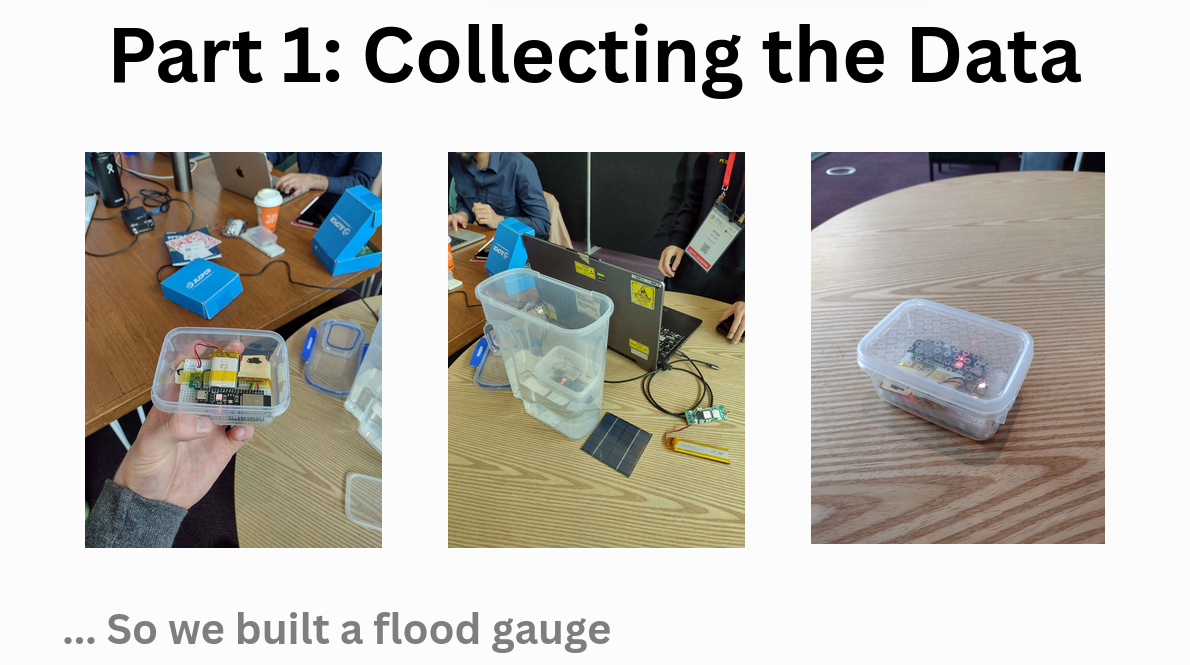
Hardware and software are open source. Build your own, or register a gauge you already run.
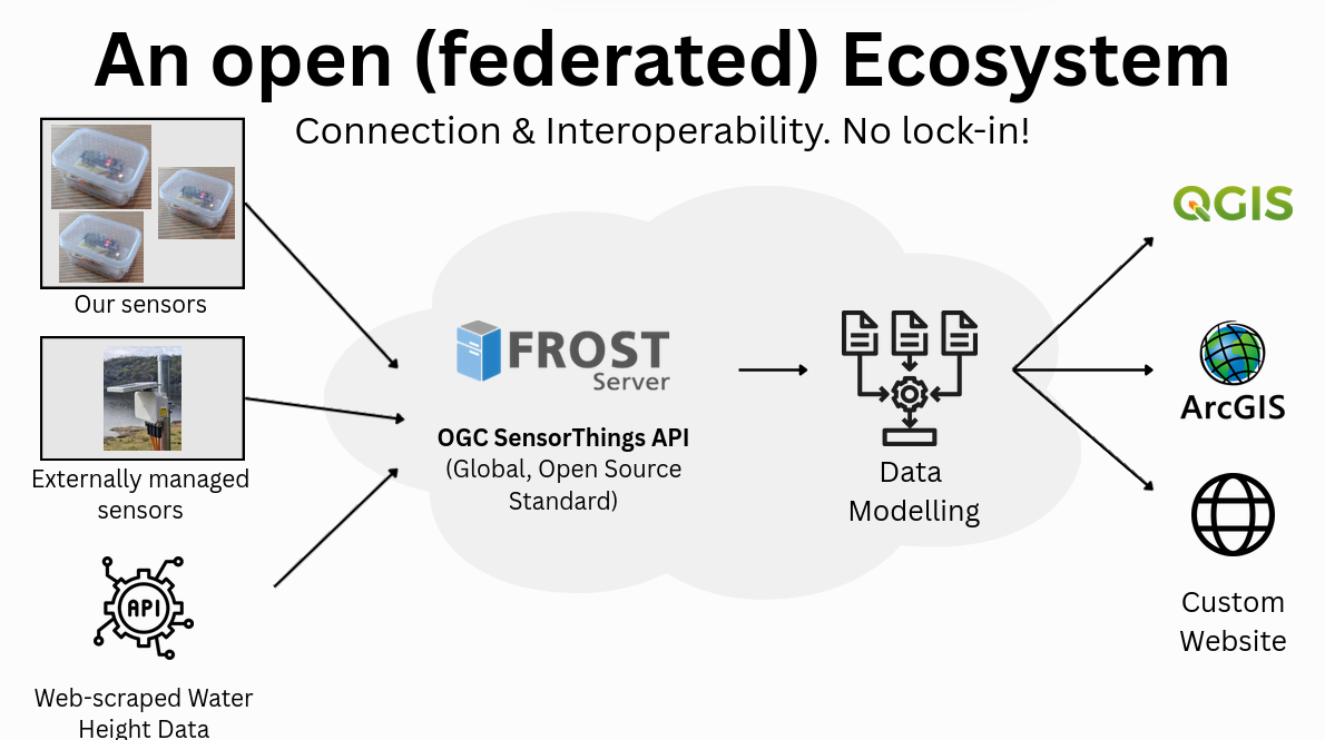
How it works
1. Ingest (Federated)
Providers post SensorThings‑compliant data to federated endpoints (FROST). Ownership remains local.
2. Model (Real‑time)
We process incoming streams and compute live flood‑extent using open methods and transparent quality checks.
3. Deliver (Overlay)
We publish a real‑time flood‑extent overlay as a web map layer—drop a single link into ArcGIS, QGIS, or your ops/SOC platform.
A federated model for real‑world governance
OpenFloodGauge is a federation. Individuals, municipalities, shires, traditional owners, and national agencies can register gauges and stream data. Ownership stays local; access is negotiated and transparent.
- Local autonomy: Shires can deploy gauges without waiting for a central body.
- National scale: Agencies can expand the network using the same APIs.
- Traditional owners: Communities run gauges on Country, retain control, and grant access on agreed terms.
- Eligibility: We accept any gauge that is accurate and compliant with OGC SensorThings.
- Revocable participation: Providers can pause or revoke feeds; access control is explicit.
Accuracy is verified using calibration runs and periodic cross‑checks. Providers keep attribution.
Governance Notes
OpenFloodGauge is federated by design. Providers retain ownership and control of their gauges and data while participating in a shared, standards‑based network. Governance emphasizes local autonomy, consent, and transparent access arrangements.
Local autonomy
Shires, municipalities, and traditional owner groups may deploy and manage gauges without requiring approval from a central authority. Operational choices (locations, maintenance schedules, calibration practices) remain local.
National scale
Regional or national agencies (e.g., DFES) can participate under the same open standards, contributing capacity and coverage while respecting local governance and attribution.
Data ownership & access
Data providers retain ownership. Publication terms are explicit and revocable. Access can be public or access‑controlled; terms (including rate limits and redistribution) are disclosed and versioned.
Indigenous data governance
Traditional owners set the conditions for collection, access, and reuse of data from gauges on Country. We follow agreed protocols and ensure attribution. Access can be time‑bound or purpose‑limited.
Quality & calibration
Providers commit to initial calibration and periodic checks. We provide guidance, test datasets, and cross‑reference against reference peaks and neighbors where available. Data flagged as uncertain is labeled downstream.
Eligibility & suspension
Any SensorThings‑compliant, accurate gauge may register. Feeds can be paused by the provider or temporarily suspended for integrity, legal, or safety reasons. All actions are logged and communicated.
Transparency
We maintain public change logs, versioned documentation, and a roadmap. Model and overlay version labels accompany delivered products to ensure traceability.
Fair access
Open APIs and documentation are publicly available. Where constraints are needed (e.g., rate limits), rules are documented and applied consistently.
Questions about governance? Email us.
Standards first
- OGC SensorThings API v1.1 (ingest, federation)
- FROST Server + PostGIS (storage & processing)
- Live overlay delivery as a standard web map layer
- CSV export & versioned documentation
Quality & fairness
- Calibration guidance & reference checks
- Transparent change logs
- Public issue tracking
- Open license for non‑sensitive datasets
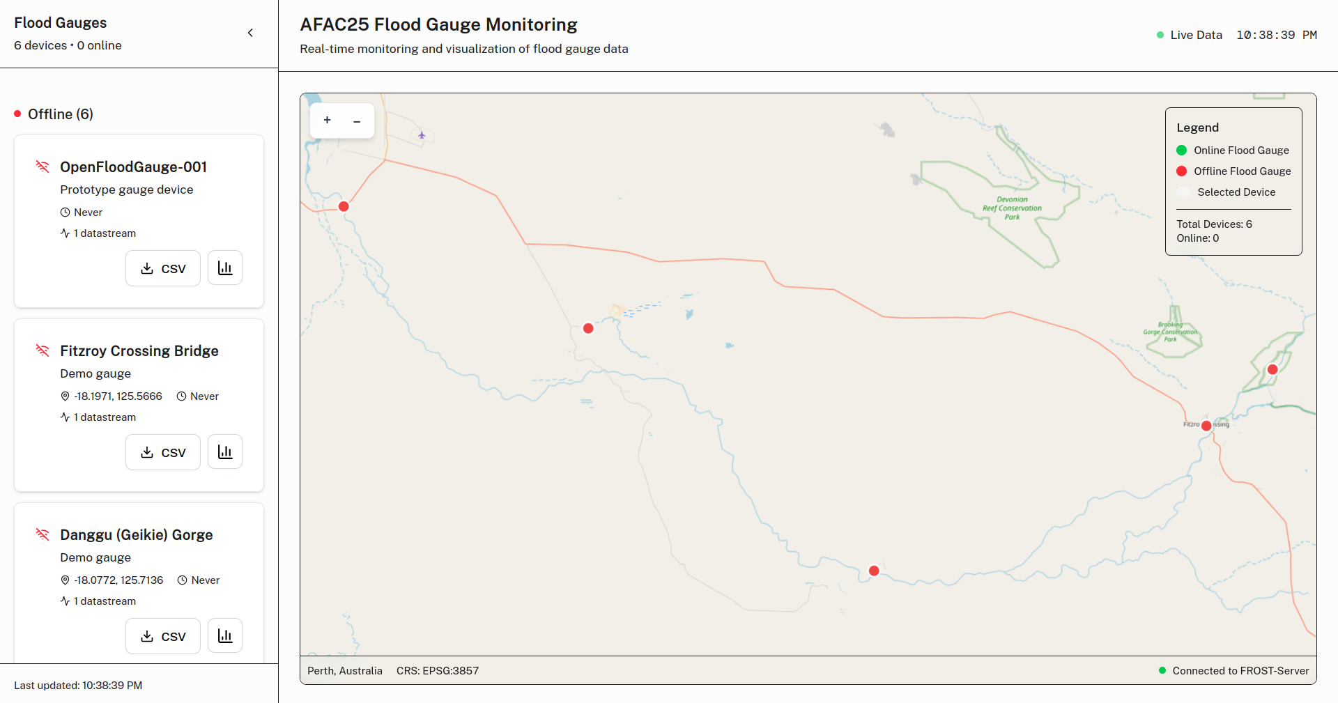
See the prototype
The demo shows our monitoring UI and an example of the live flood‑extent overlay. Features will evolve as providers and regions are added.
Open DemoFrequently asked
Do I need permission to run a gauge?
You are responsible for complying with local regulations, site access rules, and safety. If you wish to publish your data to the network, follow our registration flow and calibration steps so your stream is clearly identified, attributed, and compatible with the shared schema.
If the gauge sits on public land or on Country, obtain consent from the relevant authority or traditional owner group before installation and publication.
What accuracy is required?
We publish sensor recommendations and a calibration guide. In general, acceptable configurations achieve stable zeroing and repeatable readings across typical flow conditions. We also encourage cross‑checks after significant events and when hardware changes.
Where accuracy is uncertain, data is flagged and the overlay may down‑weight or exclude the signal until it stabilizes.
Who owns the data?
Providers retain ownership of their data. Publication terms define how the data may be accessed and reused. Attribution is preserved in metadata and, where feasible, end‑user interfaces. Providers may pause or revoke publication at any time.
How is indigenous data governed?
Data from gauges on Country is governed by the conditions set by the relevant traditional owner group. This can include access control, purpose limitations, time‑bounded access, and attribution requirements. We will not publish or redistribute such data outside agreed terms.
Can I use this in production?
Many users rely on our managed overlay for operational awareness. However, it is provided “as is” and should complement—not replace—official warnings and emergency directions. Validate the overlay in your environment and combine it with local knowledge and policies.
How do I integrate the managed overlay?
We issue a customer‑specific overlay URL. In most mapping tools, you add a Tile/WMTS/WMS/GeoJSON layer using the provided link and your token. We support ArcGIS, QGIS, and common SOC platforms. Our team can assist with onboarding and testing.
Contact
Email us at [email protected] for partnerships, media, or technical questions.
Postal
Perth, Western Australia
Media & demos
Request a walkthrough or demo access via [email protected].